motus towers project
What is the Motus Program?
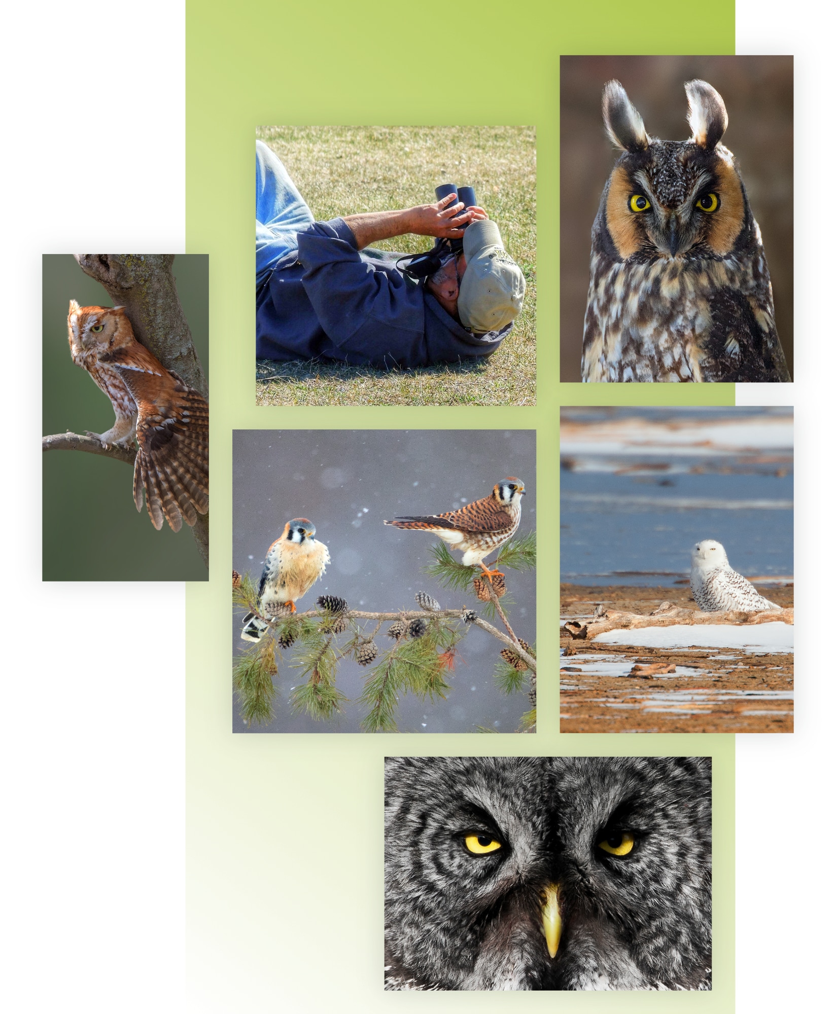
Tracking smaller birds during migration is now feasible thanks to the Motus Wildlife Tracking System, which utilizes tiny “nanotags” and dedicated stations to capture their signals. This advancement is providing researchers with crucial insights into the habitats that need protection to help conserve struggling migratory bird populations.
Motus, named for “movement” in Latin, is a wildlife tracking network that uses automated radio technology to monitor animals. It started in 2014 and quickly grew thanks to many volunteers and researchers. So far, more than 2,000 Motus receiver stations have been set up in 34 different countries.
The success of the Motus network comes from a few important features that make it very useful for scientists and conservationists. One of the most significant advantages is the tiny size of the radio tags used for tracking. These tags can weigh as little as one-tenth of a gram, which is about the same as a single pine nut. This lightweight design allows them to be attached to small birds like warblers or even insects like dragonflies while still sending back valuable data in real time.
our Motus Project and the straits
The Straits of Mackinac have been identified as a key migratory route for nearly two dozen species of birds of prey, which cross the water during their migrations twice a year. However, we’re still unsure how many other bird species or even animals like bats may also use this natural migration crossing point to travel across the Great Lakes.
This is why the Motus program is essential, because there are still significant gaps in receiver coverage due to the ongoing growth of the network. To make the most of Motus’s potential, it’s crucial to address these gaps.
To date, 40 of the 2,000+ towers are scattered across Michigan. Because of their small size, the antennas can be built almost anywhere that allows them to receive a clear signal, with some being built on military bases, college campuses and even at farmer’s markets.
Because this is new technology, northern Michigan had very limited coverage. To fill this gap, MSRW took the lead in securing funding and overseeing the development of the Tip of the Mitt Motus Network, starting with 6 towers and collaborating on a 7th.
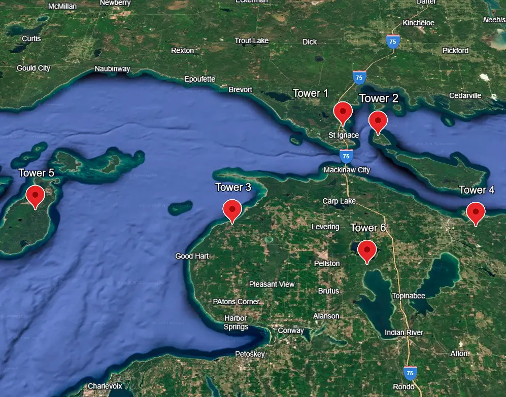
- Tower #1 is installed on the Hiawatha National Forest, St. Ignace Ranger District HQ building, just west of St. Ignace.
- Click here to view more of this Motus Tower’s details.
- Tower #2 is installed on Mackinac Island out at the airport. Because so much of the island is designated as a historic park, it can be tough to find a place to put up a 21st-century antenna. Thanks to our DNR friends at the Mackinac State Historic Parks (Myron and Justin) we were able to locate the perfect spot!
- We are still waiting on a final delivery of a special length of cable to get this tower up and running.
- Tower #3 is installed on the Wilderness State Park HQ building, west of Mackinaw City.
- Click here to view more of this Motus Tower’s details.
- Tower #4 is installed on the Michigan DNR’s Field Office building, in downtown Cheboygan.
- Click here to view more of this Motus Tower’s details.
- Tower #5 is installed at LTC’s Little Sand Bay Preserve on Beaver Island. We started from scratch there by erecting our own tower. This is also our first and only solar-powered site!
- Click here to view more of this Motus Tower’s details.
- Tower #6 is intended to be installed somewhere at the U of M Biological Station. We’re still waiting on permits.
- Tower #7 (a collaboration, not shown on map) is installed at The Greenwood Fountation in Wolverine.
- Click here to view more of this Motus Tower’s details.
What do we gain?
“The beautiful thing about this is that it is an open technology. There is no pay-to-play, and the data is free and available to everyone,” said MSRW Executive Director Scott Davis. “We all care about the conservation of these species. Because of this technology, we’re able to partner as a global community to protect them. This is the way that conservation work should be done.”
- Tracking journeys – The Motus network gives researchers valuable information about how animals migrate, find food, raise their young, and respond to changes in their environment.
- Protecting wildlife – Our data is used to develop thorough plans to protect different species that are at risk of disappearing forever.
- Working together – This network is an open research tool that promotes cooperation among different organizations for research.
- Spot problems – The network identifies environmental issues, such as habitat damage, pollution, and climate change effects.
- Community scientists – The network encourages everyday people to take part in data collection, helping them feel connected to and responsible for wildlife conservation efforts.
How Can You Help?
You can help support our mission of educating people about birds of prey and the importance of the Straits area as a migratory pathway for a wide range of wildlife.
- Support – It will cost us $2,400 each year to keep the network running. You can help us, along with other researchers who use our network, continue this vital work by donating today.
- Keep Learning – Visit the many new (and existing) pages on our website to learn more about our research projects, and to find blog updates from our researchers about their findings.
- Follow – Follow us on social media (icons in footer) and share our posts with your friends and family to help educate others about raptors.
For more details about Michigan and Motus tracking, check out a Michigan DNR article (written by our own Allye Kemme!) titled Motus Wildlife Tracking in Michigan.